To anyone standing on its shore and gazing out across its heavenly waters, the Red Sea may seem to be a mislabeling. Its blueness is eternal and anything less red cannot be fantasized. The Red Sea, where the desert meets the ocean, is truly one of the planet’s most exotic and fascinating natural seascape environments. The Red Sea is located between Asia and Africa. At its most northerly point forms the Sinai Peninsula and stretches over 1000 miles south to join the Indian Ocean, between Ethiopia and Yemen. In the north and west are desert plains, while in the south a mountainous region (2642 meters high), which is part of the mountain range stretching from deep in Saudi Arabia, across the Sinai and then into Nubia of the African continent. The Red Sea holds beneath its crystal blue surface an oasis of living creatures, reefs, and coral formation. Its use as a highway between East and West has attracted man since the beginning of time.
The Red Sea was created by the movement of plates in the Earth’s surface about 30 million years ago. In that time, the Arab peninsula started to part from Africa along a thin break line which was filled by the ocean’s water. However, "Mother Nature" did not stop there. Twenty million years ago another geological movement started. The Arab peninsula which parted from Africa, started to move to the north. That movement struck resistance in Turkey and swung to the east, and another break line was formed. This one stretching all the way from the northern part of Israel, through the Jordan valley to the Dead Sea, and finally through the Gulf of Eilat to Ras Mohamad at the southern point of the Sinai. The young age of the Gulf of Eilat is what makes it so deep, 100 meters in Dahab and 1800 meters north of the Straits of Tiran. On the other hand, the old Gulf of Suez is relatively shallow, with a 85 meters maximum depth. The Red Sea is still widening at about one-half inch per year, the rift is the youngest region of continental breakup on the planet, allowing geologists to learn about processes that occurred in the Atlantic and Pacific oceans hundreds of millions of years earlier.
Water temperatures in the Red Sea remain unusually constant year round, averaging 22^ C in the summer. Low pressure systems develop in the Sahara Desert and draw hot dry east winds from Asia which cause the temperature to rise frequently along with sand storms. At the same time, lows develop over the Red Sea, bringing moist cold air from the south and creating clouds, haze, and more often rain. The northern land mass is the primary influence over temperature in the gulf, but this decreases to the south the closer you get to open sea. The open sea’s cooling effect creates an interesting temperature pattern: maximum summer temperatures are lower in the south while minimum temperatures are higher in the north with the opposite occurring during the winter. In any case, the coldest moth of the year is January and the warmest months are July and August. The Red Sea is notorious among seafarers for its high speed surface winds and aggressively short irregular motion. It may be calm on the inward shore, but journeys to exposed sites like The Brothers islands, a remote off-shore site east of El Quseir, can be perilous and boats have been seen literally to fall apart under the force of the journey.
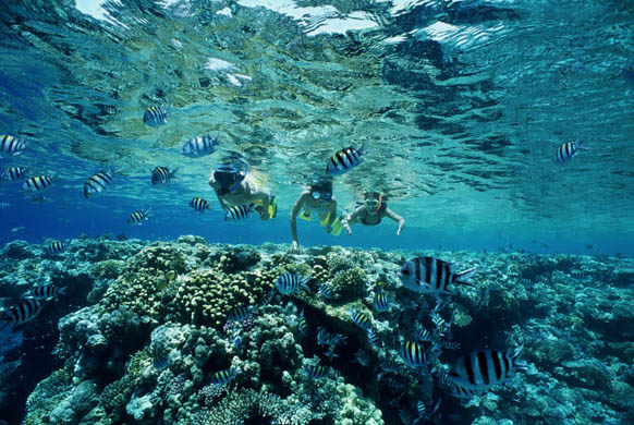
Cargo vessels, oil tankers, fishing boats, and passenger liners all move their trade across this great waterway, but for many, the true enchantment of the Red Sea is hidden just below its surface. There are over 1000 species of invertebrates and around 200 recorded coral types to be found. Moreover, the Red Sea boasts over a thousand species of fish, more species than any other proportional body of water. Not surprisingly, therefore, the Red Sea is considered by many to offer the very best diving available in the marine world. The Red Sea attracts divers, photographers, marine scientists, and leisure seekers from all over the world, hoping to experience and explore the incalculable wonders of the colorful, abounding marine life and the Red Sea’s lavish coral reefs. In places, the exceptional living reef stretches way out to sea, forming a elaborate system of caves, lagoons, gardens, and plateaus. Some of these coral summits plunge dramatically thousands of feet to the ocean floor. The Red Sea is not all a delight however, as it has its troubles which you will have to stay away from. There is minimal danger from marine animals in the Red Sea, and with a little common sense, even these dangers can be eliminated. Some of the marine animals are dangerous to touch, others dangerous to eat, and some are dangerous to come face to face with. There are fire corals and stinging hydroids which can be extremely painful if accidentally touched as well.
Snorkeling is a popular way to view the edge of the reef, especially for those with limited confidence in their swimming ability. Sharks, manta rays, turtles, and eels will take pieces of bread from your hand, and brilliantly colored schools of fish team all around in bewildering color. However, most divers will tell you that there is nothing to beat the thrill of experiencing the depth of the reef and the abounding marine life to be found in the Red Sea. The lure of the reef is such that many novice divers become totally "hooked" and cannot imagine why they have never joined in the fun before. Furthermore, when asked to compare their local diving conditions with those in the Red Sea, they find it a "paradise" with clear visibility, little wave action, and warm temperatures all year long.
Fishing is an art which still preserves time-honored methods, mostly due to the difficulties imposed by the dangers of the reef. The hook-and-line method of fishing has been in use for more than four thousand years and is still going strong. Conservation of certain species of fish and the dangers of over-fishing are both important issues for the government. The fisherman land a total of 8,000 metric tons of fish per year, which, although eight times as much as the Sudan, is less than half Egypt’s total catch.
The water of the Red Sea is also a vital asset. Surrounding cities are totally dependent on it for household and industrial supplies, and tremendous desalination plants are in operation. These supply drinking water which has been purified to a high standard, as well as non-potable domestic water. Sea water is also used in large quantities by oil refineries and cement works situated along the coastline. The danger of pollution is always present in the Red Sea, particularly from oil spillage. A Royal Decree forbids the discharge of any pollutant substances, including oil, within 100 miles of the Saudi Arabian coastline.
Currently, the areas of the Eastern Desert and around the Red Sea have received a great deal of overdue attention. A joint expedition from the University of Delaware and Leiden University and Leiden University has been working at the ancient Red Sea port of Berinike. The past season the Delaware-Leiden team excavated in two areas, opened a total of seven trenches, and found four public buildings. One of the sites contained offering tables, an incense burner, a stela stand and an almost life-size bronze figure of a cloaked woman clasping a snake. Scraps of colorful textile from the Fourth and Fifth centuries A.D. have also been found. In addition, evidence of trade appears in the form of imported coconuts, pepper, and rice. So, while the edges of the Red Sea are being explored, the sea itself is being plunged in a survey of sunken wrecks. The Institute for Nautical Archaeology in Egypt, is continuing the underwater survey started last season, plotting the locations of shipwrecks along the Red Sea coast.
For swimmers, divers, traders, industrialists, fishermen, archaeologists, and tourists, the Red Sea has its own kind of incomparability. And even the leisured gazer, speculating the inaccessible blue/red abnormality, can be said to have been given something to think about. The underwater amazement of the Red Sea remains a living tapestry of resounding corals and exotic fish, waiting for you to discover its secrets.


")


 Right - The west bank across the Nile from Luxor.
  Within Luxor, there are only three main streets consisting of Sharia al-Mahatta, Sharia al-Karnak and the Corniched, next to the Nile. The street in front of the train station is Sharia al-Mahatta and runs away from the Nile where it meets the gardens of Luxor Temple. Sharia al-Karnak, or Maabad al-Karnak which means Karnak Temple Street runs along the Nile from Luxor Temple to Karnak Temple. However, Sharia al-Karnak is known as Sharia al-Markaz where it meets Sharia al-Mahatta street, and to the south around the temple it is known as Sharia al-Lokanda. Along this street one will find the colorful signs of restaurants and cafes, as well as bazaars where the usual variety of Egyptian souvenirs can be found. Of interest is the alabaster, which is plentiful along the west bank and miled not far from here. Also look for the clay pots used by the locals for cooking, which are more unusual.
 In Luxor proper on the East Bank, one of the first stops must be the
 About halfway to Karnak, you will discover the Luxor Museum. (The image at left is a Block Statue of Iamu Negh from the Luxor Museum). It should certainly be visited if you plan a well rounded and educated experience. While this is a small museum, most of the relics are from the surrounding area and provide considerable insight to the monuments you will visit.
 To arrive at the entrance one follows the dromos with its crio-sphinxes. They have the head of a Ram and the body of a lion and are symbolic of the God Amun. Arriving at the temple, there is a statue of Ramesses II with his son between his feet.